Stelvio natural enduro trails
/in MTB trails/by Admin-2k23Stelvio natural enduro trails
The best Enduro and All Mountain trails
Stelvio Natural Enduro Trails:
Thrilling descents amidst unmissable views
After the comfortable and quick cable car ride from S. Caterina, are you ready for the descent?
Fun trails will take you from the 2,800 metres of Cresta Sobretta, in the Alpe Valley, down to S. Caterina Valfurva (1,700 m).
With Stelvio Natural Enduro Trails you will discover breathtaking views on natural trails with varying gradients and exciting passages thanks to the existing trail network.
If you love the adrenaline rush of downhill riding combined with the pleasure of pedaling on trails with a lot to tell, S. Caterina is the right place for you!
DYNAMITE TRAIL + LINE
Length
12.9 km
Difficulty
S3
Descent gradient
1066 m
Duration
1 hour and 30 minutes
SUNNY VALLEY TOUR
Length
12 km
Difficulty
S2
Descent gradient
1021 m
Duration
1 hour 15 minutes
DOS BOLON
Length
5.1 km
Difficulty
S3
Descent gradient
585 m
Duration
45 min
Rental – technical clothing – lifestyle – MTB accessories and spare parts
Whether you are an expert cyclist, a nature lover or a curious explorer, Rossignol Store is the perfect starting point to experience Santa Caterina and its surroundings and its breathtaking landscapes!
Sunny Valley – Croce Monte Sobretta
/in Trekking trails/by Admin-2k23Sunny Valley – Croce Monte Sobretta
Easy route, suitable for everyone
AN EASY AND EXCITING ROUTE THAT LEADS TO THE TOP OF MOUNT SOBRETTA
The trail starts from the Sunny Valley refuge and leads to the summit of Monte Sobretta , offering a breathtaking trekking experience in the Stelvio National Park.
Starting from the refuge at 2,700 meters, the trail winds through alpine meadows and scree slopes, climbing to the summit of Monte Sobretta at 3,296 meters. Here, you’ll find an imposing tubular cross erected in 1968 and the Rosa dei Monti (mountain rose), which offers a 360-degree view of the peaks of the Ortles-Cevedale , extending your gaze toward the Bernina Range and all the way to the Dolomites.
Along the way, you can spot wild animals (chamois, marmots, bearded vultures) and enjoy the peace and tranquility of nature.
The return follows the same route to the Sunny Valley Refuge.
Technical information hike
Departure
Sunny Valley Shelter
Arrival
Sobretta Mountain Peak
Descent gradient
3 m
Elevation gain
651 m
Difficulty
Easy
Length
4 km 800 m
Duration
2 hours 21 minutes
Trail map
Relax and enjoy good Valtellina food at Sunny Valley
Sunny Valley has a Steakhouse Restaurant and a Gourmet Restaurant where you can enjoy tasty local food.
Sunny Valley – VallAlpe – St. Catherine
/in MTB trails/by Admin-2k23Sunny Valley – VallAlpe – Santa Caterina
Adrenaline-filled Mountain Bike route
A breathtaking descent into the heart of the Stelvio National Park h2 >
Looking for an exciting freeride mountain bike route?
Try the Sunny Valley – VallAlpe – Santa Caterina itinerary!
We recommend starting from the Sunny Valley refuge, easily reached with the S. Caterina-Vallalpe cable car open all summer.
Taking the S. Caterina-Vallalpe cable car, from the village of Santa Caterina, you can take your mountain to the top at no additional cost and enjoy 100% an unforgettable experience at high altitude. p>
Once you reach the Sunny Valley refuge you can start a fun descent towards the valley during which you will encounter, in this order, the Malga dell’Alpe, the Ponte delle Vacche, and then, following, the Tresero forest and the Località Centrale strong>, until you arrive in about 2 hours and 45 minutes at Santa Caterina Valfurva where you can relax in complete tranquility and enjoy the local beauties.
Technical excursion information
Departure
Rifugio Sunny Valley
Arrival
Santa Caterina Valfurva
Descent height difference
990 m
Difference in altitude ascent
994 m
Difficulty
Medium
Length
8 Km 500 m
Duration
2 h 45 min
Rental – technical clothing – lifestyle – MTB accessories and spare parts
Whether you are an expert cyclist, a nature lover or a curious explorer, Rossignol Store is the perfect starting point to experience Santa Caterina and its surroundings and its breathtaking landscapes!
Sunny Valley – St. Catherine
/in MTB trails/by Admin-2k23Sunny Valley – Santa Caterina
Mountain bike trail among the ski slopes of Valfurva
Only in Santa Caterina Valfurvacan you experience the thrill of downhill mountain biking on Valtellina’s most renowned ski slopes.
If you are a mtb enthusiast, you can’t miss this fun opportunity!
From the Sunny Valley hut, at an elevation of 2,700 meters, the descent begins.
Riding your mountain bike, you can plow the paths of the Alpe winter trail to the middle station of the Plaghera gondola.
From there, you can continue on the lower part of the Deborah Compagnoni winter slope and end your ride in Santa Caterina, a stone’s throw from the S. Caterina-Vallalpe gondola.
Technical excursion information
Departure
Rifugio Sunny Valley
Arrival
Santa Caterina Valfurva
Difficulty
Medium
Length
7 Km 500 m
Duration
1 h
Rental – technical clothing – lifestyle – MTB accessories and spare parts
Whether you are an expert cyclist, a nature lover or a curious explorer, Rossignol Store is the perfect starting point to experience Santa Caterina and its surroundings and its breathtaking landscapes!
Sunny Valley – Alp Pond
/in MTB trails/by Admin-2k23Sunny Valley – Laghetto dell’Alpe
Panoramic Mountain Bike Route
A fascinating ride through the breathtaking views of Valfurva
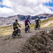
A circular mountain bike trail,suitable for the whole family, completely immersed in nature.
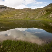
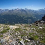
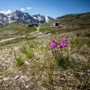
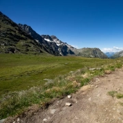
Starting from the Sunny Valley refuge, on your mountain bike, you can ride along the entire Laghetto dell’Alpe and stop to admire, every now and then, the bright colours of the flowers and meadows in summer, the dense woods and the immensity of the mountains that surround you, such as Mount Sobretta.
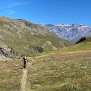
The trail, from Sunny Valley, is easy and relaxing, in fact, it is possible to complete the tour in about 1 hour of calm pedaling.
We therefore recommend starting the route in the late morning so as to arrive for lunch at Sunny Valley where you can taste excellent Valtellinese food, healthy and genuine, at high altitude, and sip some good red wine.
Until sunset, the entire valley that hosts Sunny Valley is sunny and warm. We therefore recommend that you bring your swimsuit with you and try the brand new solarium of Sunny Valley, furnished with taste and style, to ensure extreme comfort.
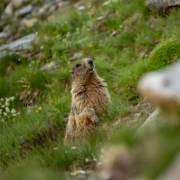
You will be able to enjoy the fresh mountain sun as much as possible and relax listening to the sounds of nature and animals of the place.
For a family day dedicated to well-being, sport and relaxation in the pure nature of the mountains, choose the mountain bike route: Sunny Valley – Laghetto dell’Alpe.
Technical excursion information
Departure
Rifugio Sunny Valley
Arrival
Rifugio Sunny Valley
Descent height difference
155 m
Difference in altitude ascent
157 m
Difficulty
Easy
Length
3 Km 221 m
Duration
1 h 4 min
Trail map
Rental – technical clothing – lifestyle – MTB accessories and spare parts
Whether you are an expert cyclist, a nature lover or a curious explorer, Rossignol Store is the perfect starting point to experience Santa Caterina and its surroundings and its breathtaking landscapes!
Great War Trail
/in Trekking trails/by Admin-2k23Great War Trail
Historic trekking route
A challenging walk exploring the remains of the Great War
Trekking trail suitable for experienced walkers.
Starting from the Sunny Valley refuge, you will immediately encounter the mule track hand-built by the soldiers (S564) and the rocky trenches used as shelter and refuge during the long war season: a sight to immortalize in a photograph that will remember the courage and suffering experienced by so many young people in the name of freedom and their homeland.
The trek continues towards Passo dell’Alpe – Mot De Li Leur (S519) and goes up the Piano del Termine , full of hairpin bends with a maximum gradient of 449 metres.
As mentioned, the circular route starting and finishing at Sunny Valley is challenging and the average travel time is around 3 hours.
Historical Notes
In the winter of 1915, the year in which the Great War began, Santa Caterina Valfurva, with its Ortles-Cevedale-Adamello mountain giants connecting to the chain of Alps via the Stelvio Pass and the Gavia Pass, became a strategic military point for the defense of our borders.
Military defense lines were built at a height of 3000 meters , where panoramic and lookout points overlooking the surrounding valleys guaranteed a perfect view of the enemy’s advance intentions and moves.
Amid the snow and crippling cold, typical of winter in Santa Caterina Valfurva, were erected: trenches, artillery emplacements, and caves for the troops .
Today, walking along the mountain paths of Valfurva and, in particular, the Sunny Valley – Passo Dell’Alpe – Mot De Li Leur – Piano del Termin path , it is possible to find barbed wire fences, inlets dug into caves for sentries to station, bridges and stone pavements built by soldiers to reach the highest strategic points for defence.
Today, Santa Caterina Valfurva is, therefore, a place that bears witness to the tragic history of our people and guardian of the pain of the young soldiers engaged in the front.
Technical information hike
Departure
Sunny Valley Shelter
Arrival
Sunny Valley Shelter
Descent gradient
438 m
Elevation gain
439 m
Difficulty
Average
Length
7 km 600 m
Duration
3 hours 4 minutes
Trail map
Relax and enjoy good Valtellina food at Sunny Valley
Sunny Valley has a Steakhouse Restaurant and a Gourmet Restaurant where you can enjoy tasty local food.
Alpe Bridge – Alpe Valley – Sunny Valley
/in Trekking trails/by Admin-2k23Alpine Bridge – Alpine Valley – Sunny Valley
Historical trekking trail
A walk through the history that marked the places of Santa Caterina,
from the Mesolithic era to the Great War
Scenic trekking trail of medium difficulty mostly uphill to be hiked in company for fun.
We recommend that you leave your car in the car park near Ponte dell’Alpe – Paso Gavia road and begin the hike along path S519 where you can discover the remains of settlements from the Mesolithic era .
We continue on path S564 towards the wide and bright Valle dell’Alpe, crossed by the majestic Alpine stream where you can stop to photograph the rocky panorama, full of pebbles and large boulders.
Further up the valley, you’ll come across the remains of trenches and forts from the Great War carved into the rock; a real treat for the curious and history buff.
Soon you will arrive at the Sunny Valley refuge where you can pamper yourself with quality food and local wine.
Technical information hike
Departure
Alp Bridge
Arrival
Sunny Valley Shelter
Descent gradient
5 m
Elevation gain
353 m
Difficulty
Average
Length
3 km 900 m
Duration
1 hour 40 minutes
Trail map
Relax and enjoy good Valtellina food at Sunny Valley
Sunny Valley has a Steakhouse Restaurant and a Gourmet Restaurant where you can enjoy tasty local food.
Sunny Valley – Malga Dell’Alpe
/in Trekking trails/by Admin-2k23Sunny Valley – Malga Dell’Alpe
Scenic hiking trail
A relaxing panoramic hike in the pristine nature of Valfurva
Starting from the Sunny Valley refuge , you descend along a panoramic path that opens onto green pastures and mighty mountains .
From this viewpoint you can admire the majesty of Monte Tresero and the depth of the Gavia Pass Valley, characterized by numerous hills, inlets, and side valleys that offer various trekking opportunities.
The clear blue stream of the Alpe accompanies the descent through the pastures where the calm and tranquility of a true fairytale landscape reigns.
You will then arrive at the Malga dell’Alpe : a beautiful mountain pasture farmhouse located on the Gavia road, a few meters from the Alpe bridge , where it is possible to taste and buy typical Valtellina products as well as have an exciting experience in direct contact with the animals. of the farm.
Technical information hike
Departure
Sunny Valley Shelter
Arrival
Malga Dell’Alpe
Descent gradient
345 m
Elevation gain
2 m
Difficulty
Average
Length
3 km 200 m
Duration
54 min
Trail map
Relax and enjoy good Valtellina food at Sunny Valley
Sunny Valley has a Steakhouse Restaurant and a Gourmet Restaurant where you can enjoy tasty local food.
Marmot Route
/in Trekking trails/by Admin-2k23Marmot Route
Nature loop trail for trekking
An exciting trekking excursion to discover marmots: the largest rodent in the Alps.
Loop trail, suitable for all families, going around the Sunny Valley refuge, discovering and searching for marmots and their typical whistles.
Technical information hike
Departure
Sunny Valley Shelter
Arrival
Sunny Valley Shelter
Descent gradient
48 m
Elevation gain
51 m
Difficulty
Average
Length
1 km 600 m
Duration
31 min
Trail map
Relax and enjoy good Valtellina food at Sunny Valley
Sunny Valley has a Steakhouse Restaurant and a Gourmet Restaurant where you can enjoy tasty local food.
Sobretta Ridge – Sunny Valley
/in Trekking trails/by Admin-2k23Sobretta Ridge – Sunny Valley
Trekking trail with a view
AN ITINERARY WITH ENCHANTING PANORAMIC POINTS TO IMMORTALIZE IN A PHOTOGRAPH
A medium-difficulty trekking trail, the Cresta Sobretta – Sunny Valley itinerary or vice versa requires adequate sports equipment such as specific trekking shoes and windproof jackets to best enjoy the view at the highest point reached by the cable car at 2,860 m.
We recommend starting your hike right here and then enjoying lunch at the magnificent Sunny Valley restaurant and a sunny, peaceful afternoon on the refuge’s solarium.
Using the cable car stop on the crest, you immediately reach the first panoramic point near the former Sobretta refuge, where you can admire the vastness of the Ortles-Cevedale and Adamello mountain ranges and a view of the valley floor with the village of Santa Caterina.
From here the hike winds along the ridge (path S563) and then descends towards the basin with a beautiful glacial lake until reaching the Sunny Valley Refuge (S562 and S560.1) in about an hour’s walk.
Technical information hike
Departure
Sobretta ridge gondola
Arrival
Sunny Valley Shelter
Descent gradient
253 m
Elevation gain
180 m
Difficulty
Average
Length
3 km 100 m
Duration
1 hour 17 minutes


